

NISAR Unleashed: Earth from a New Lens
Exploring the Pulse of the Planet with Cutting-Edge SAR Technology

The NISAR (NASA-ISRO Synthetic Aperture Radar) satellite is a collaborative project between NASA (National Aeronautics and Space Administration of the United States) and ISRO (Indian Space Research Organisation). This joint mission aims to design, develop, and launch a dual-frequency synthetic aperture radar (SAR) satellite to observe and take measurements of the Earth's surface. NISAR is designed to provide an unprecedented detailed view of the Earth using advanced radar imaging to study and understand natural processes and environmental changes.

Recently NISAR was in news, brief from a news article:
The radar antenna reflector on the NISAR satellite is being shipped back to the US for an additional "special coating", as the space agencies work toward a new launch window for the earth observation satellite.
In today’s article we will unleash in detail, step by step, about SAR (Synthetic Aperture Radar) in order to understand NISAR. The spacecraft will accommodate two fully capable synthetic aperture radar instruments (24 cm wavelength L band SAR and 10 cm wavelength S band SAR). Hence, it is a dual band, but what is the this L-band and S-band?
The L-band and S-band are segments of the microwave band of the electromagnetic spectrum, which is used for a wide range of communication, radar, and navigation applications. Each band has its unique properties and applications, influenced by factors such as wavelength, frequency range, and penetration capabilities.

L-band
Frequency Range: The L-band spans from 1 to 2 GHz.
Characteristics: This band offers a balance between range and resolution, with relatively low atmospheric attenuation compared to higher frequency bands. It's well-suited for penetrating through vegetation and can be used in various weather conditions.
Applications: Satellite communication, GPS, air traffic control and remote sensing.
S-band
Frequency Range: The S-band covers frequencies from 2 to 4 GHz.
Characteristics: The S-band is characterized by its ability to provide moderate range and resolution for radar and communications, with better penetration through rain or fog than higher frequency bands.
Applications: Radar, satellite communication, shipboard and coastal radars and wireless networks.
Key Differences and Considerations
Propagation and Penetration: The L-band, with its lower frequency range, generally offers better penetration through obstacles and can be less affected by atmospheric conditions compared to the S-band. This makes it particularly useful for applications requiring signals to pass through vegetation or other obstructions.
Bandwidth and Capacity: The S-band, being at a higher frequency, can potentially offer higher data transmission rates compared to the L-band, beneficial for certain communication applications.
Application Specificity: The choice between L-band and S-band depends heavily on the specific requirements of an application, including the need for penetration, range, resolution, and susceptibility to atmospheric conditions.
Now let’s discuss about Synthetic Aperture Radar (SAR)
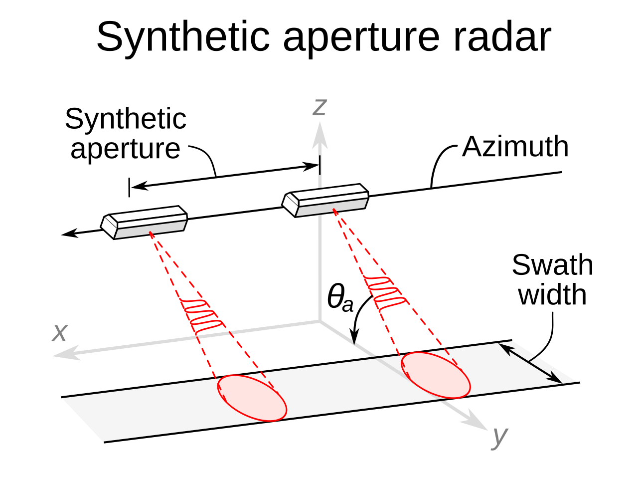
SAR is an advanced form of radar technology used to create detailed images of the Earth's surface, regardless of weather conditions or the time of day. Unlike traditional optical imaging, which relies on sunlight and can be obstructed by clouds or lack of light, SAR can penetrate through clouds and darkness to capture high-resolution images. This capability makes SAR an invaluable tool for a wide range of applications, including environmental monitoring, earth sciences, agriculture, and military reconnaissance.

How SAR Works
SAR operates from airborne or spaceborne platforms, such as airplanes or satellites. It emits microwave radar signals towards the Earth's surface and captures the reflected signals to form images. The 'synthetic aperture' in the name refers to the method of using the motion of the radar antenna over a targeted area to simulate a much larger antenna or aperture electronically. This process significantly enhances the resolution of the images captured.
The key principles behind SAR imaging include:
Radar pulses: SAR systems send out bursts of radio waves (microwave radiation) and measure the energy that bounces back from the Earth's surface.
Relative movement: The radar antenna moves relative to the target area. As the platform (airplane or satellite) carrying the radar moves, it continually records the return signals from the ground. This movement allows the radar system to simulate a much larger antenna than its physical size, hence the term "synthetic aperture."
Data processing: The returned signals are processed to construct images of the Earth's surface. The phase and amplitude of the incoming waves, which change depending on the distance and characteristics of the reflecting surface, are used to create detailed images.
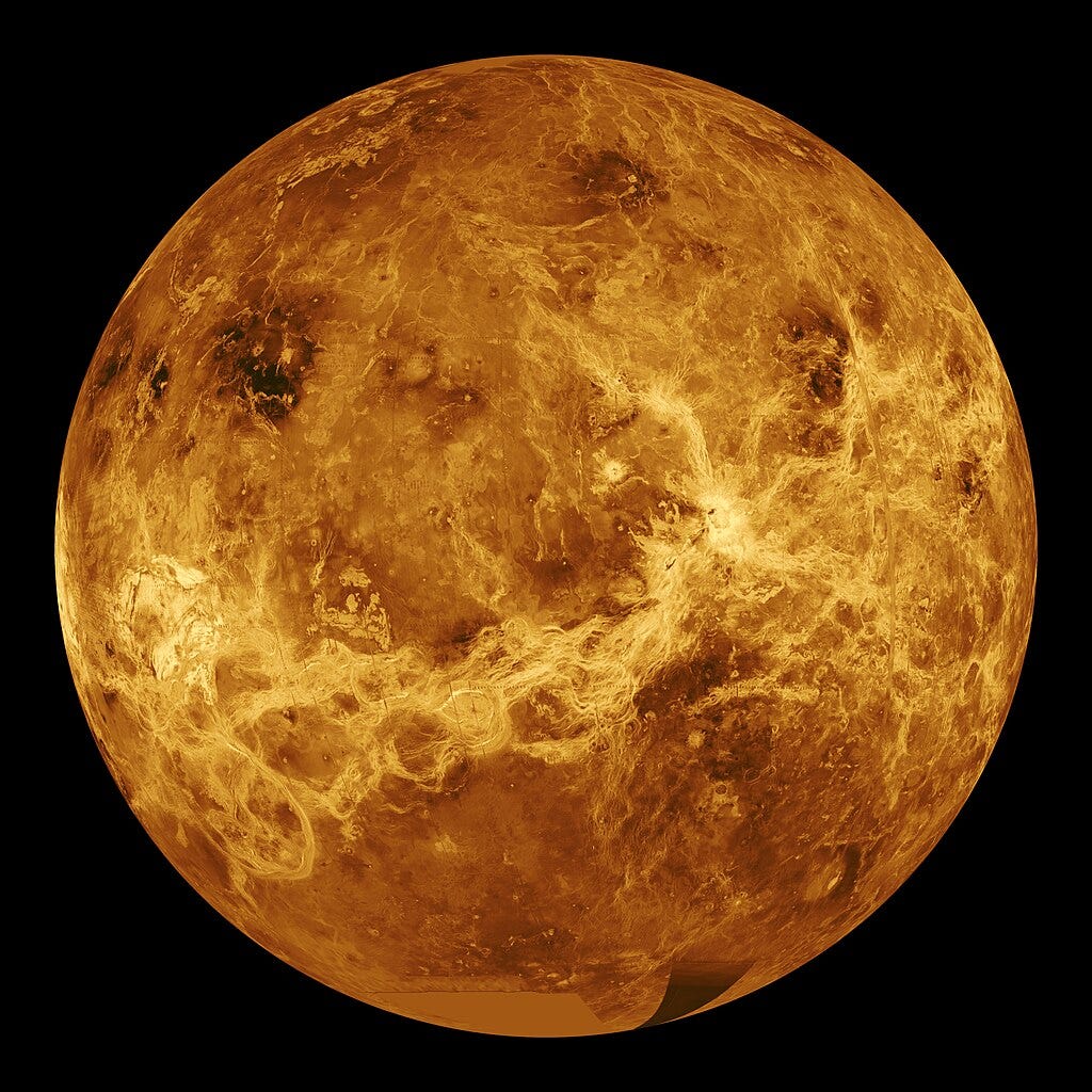
The surface of Venus, as imaged by the Magellan probe using SAR

While SAR offers unique advantages, it also presents challenges such as the complexity of data interpretation. The radar signals can be affected by surface roughness, angle of incidence, and material properties, requiring sophisticated algorithms to accurately interpret the data. Additionally, SAR systems and data processing are technologically complex and resource-intensive.